|
Historical Map
1.0
Plugin for automatic extraction of old forest from historical map
|
|
Historical Map
1.0
Plugin for automatic extraction of old forest from historical map
|
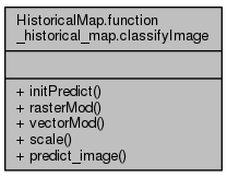
Classify image with learn clasifier and learned model. More...

Public Member Functions | |
| def | initPredict |
| def | rasterMod |
| def | vectorMod |
| def | scale |
| Function that standardize the data. More... | |
| def | predict_image |
| The function classify the whole raster image, using per block image analysis. More... | |
Classify image with learn clasifier and learned model.
Create a raster file, fill hole from your give class (inClassForest), convert to a vector, remove parcel size which are under a certain size (defined in inMinSize) and save it to shp.
Input :
    inRaster : Filtered image name ('sample_filtered.tif',str)
    inModel : Output name of the filtered file ('training.shp',str)
    outShpFile : Output name of vector files ('sample.shp',str)
    inMinSize : min size in acre for the forest, ex 6 means all polygons below 6000 m2 (int)
    TODO inMask : Mask size where no classification is done                                     |||| NOT YET IMPLEMENTED
    inField : Column name where are stored class number (str)
    inNODATA : if NODATA (int)
    inClassForest : Classification number of the forest class (int)

Output :
    SHP file with deleted polygon below inMinSize
Definition at line 312 of file function_historical_map.py.
| def HistoricalMap.function_historical_map.classifyImage.initPredict | ( | self, | |
| inRaster, | |||
| inModel | |||
| ) |
Definition at line 334 of file function_historical_map.py.
| def HistoricalMap.function_historical_map.classifyImage.predict_image | ( | self, | |
| inRaster, | |||
| outRaster, | |||
| model, | |||
inMask = None, |
|||
NODATA = -10000, |
|||
SCALE = None |
|||
| ) |
The function classify the whole raster image, using per block image analysis.
The classifier is given in classifier and options in kwargs
Input :
inRaster : Filtered image name ('sample_filtered.tif',str) outRaster :Raster image name ('outputraster.tif',str) model : model file got from precedent step ('model', str) inMask : mask to NODATA : Default set to -10000 (int) SCALE : Default set to None
Output :
nothing but save a raster image
Definition at line 492 of file function_historical_map.py.
| def HistoricalMap.function_historical_map.classifyImage.rasterMod | ( | self, | |
| rasterTemp, | |||
| inClassForest | |||
| ) |
Definition at line 364 of file function_historical_map.py.
| def HistoricalMap.function_historical_map.classifyImage.scale | ( | self, | |
| x, | |||
M = None, |
|||
m = None |
|||
| ) |
Function that standardize the data.
Input: x: the data M: the Max vector m: the Min vector Output: x: the standardize data M: the Max vector m: the Min vector
Definition at line 460 of file function_historical_map.py.
| def HistoricalMap.function_historical_map.classifyImage.vectorMod | ( | self, | |
| rasterTemp, | |||
| inMinSize, | |||
| outShpFile | |||
| ) |
Definition at line 406 of file function_historical_map.py.
 1.8.6
1.8.6